Airships can reveal everything about the forest – tree by tree
- Article
Data that provides knowledge about forests and land is a valuable tool for optimizing forestry toward even greater resource efficiency. That’s why SCA maps its forest holdings using drones, and now also an autonomous airship.
“Technological tools are an important component in obtaining better data for planning, both for individual harvests and long-term management of larger forest areas. Therefore, it’s natural to be positive toward new technology and to dare to evaluate new tools,” says Magnus Bergman, SCA Forest’s Head of Technology and Digitalization.
By gathering information about forest age distribution, tree species composition, standing biomass volume, and soil conditions, a “digital twin” of the forest can be created. SCA has long collected and processed this type of data through aerial photography and scanning using drones and helicopters.
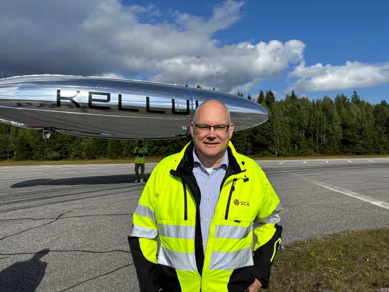
This year, work has also begun in Västernorrland with a 12-meter-long remotely operated airship. The airship can stay airborne for up to half a day, travel long distances, and is powered by a hydrogen fuel cell.
“It has many similarities with what we already do with helicopters and drones, but the airship has some unique features in that it can cover large areas, remain airborne for a very long time, and has significantly lower operating costs than, for example, helicopter flights,” says Magnus Bergman.
The flights, operated by Finnish company Kelluu, are part of the EU project SingleTree, which aims to map and monitor trees at an individual level. The purpose is to explore how forest value chains can be optimized using information about individual trees combined with AI and remote sensing.
“As a company, we are already quite advanced in this work and have solid knowledge at the stand level, but we are very eager to get even closer and learn as much as possible about each individual tree. When we have a digital twin of the forest, work planning becomes faster, more efficient, and more accurate. It also frees up time and resources for more extensive field visits to areas we want to examine more closely for various reasons,” says Magnus Bergman.
From a broader forestry perspective, what can one hope to achieve from an EU-wide project?
“In Sweden, we’re very good at collecting data about our forests, but that’s not the case everywhere in the world – not even across the EU. A larger, shared knowledge base enables better comparisons and follow-ups between different regions, their conditions, and which forestry methods and measures work well or less well in different parts of the EU,” says Magnus Bergman.
“In our own operations, we see that more information and better planning in both the short and long term also help to maintain net growth in the forests and use the forests we have in the most resource-efficient way. If we can help achieve similar results in more regions within the EU, that’s obviously a very positive outcome for everyone,” says Magnus Bergman.

Related content

SingleTree and SCA explore the future of forestry – with airships and AI
In August, SCA Skog hosted the annual meeting for the EU project SingleTree. Among the participants were Europe's leading researchers in digital technology and forestry. "These were rewarding days where we showcased SCA's operations and our digital forestry. We’ve had many interesting presentations and discussions, and we got to see an airship that can measure forests," says Magnus Bergman, SCA Skog.

An innovation that maximizes the potential of raw material
At SCA we see opportunities in developing new applications for our Swedish forest resources. Heat-treated Lodgepole Pine is one result of this innovation process, a product that combines dimensional stability, durability, and an attractive appearance. Through heat treatment, Lodgepole Pine gains properties similar to heartwood, opening up many new areas of use.

Where climate-benefit-rich forests of the future are created
With a combination of well-managed forests and high-quality cultivated seedlings, the size of Sweden’s forests increase every year. Nurseries have long been a key part of the development of the forestry industry and are becoming increasingly important in the face of climate change. Laboratory engineer Jeanette Hammarström, from SCA NorrPlant, talks to us about SCA’s cultivation activities.